


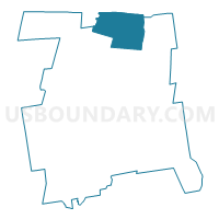
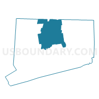
Suffield 1 Voting District, Hartford County, Connecticut
About
Outline

Summary
| Unique Area Identifier | 549636 |
| Name | Suffield 1 Voting District |
| County | Hartford County |
| State | Connecticut |
| Area (square miles) | 42.94 |
| Land Area (square miles) | 42.26 |
| Water Area (square miles) | 0.68 |
| % of Land Area | 98.42 |
| % of Water Area | 1.58 |
| Latitude of the Internal Point | 41.99991490 |
| Longtitude of the Internal Point | -72.67875090 |
Maps

Graphs
Select a template below for downloading or customizing gragh for Suffield 1 Voting District, Hartford County, Connecticut


Neighbors
Neighoring Voting District (by Name) Neighboring Voting District on the Map
- Agawam Precinct 6, Hampden County, MA
- Agawam Precinct 7, Hampden County, MA
- Agawam Precinct 8, Hampden County, MA
- East Granby 61 Voting District, Hartford County, CT
- East Granby 62 Voting District, Hartford County, CT
- Enfield 2A-58 Voting District, Hartford County, CT
- Enfield 2B-58 Voting District, Hartford County, CT
- Enfield 4B-58 Voting District, Hartford County, CT
- Granby 1 Voting District, Hartford County, CT
- Longmeadow Precinct C, Hampden County, MA
- Southwick Precinct 2, Hampden County, MA
- Southwick Precinct 3, Hampden County, MA
- Windsor Locks 1 Voting District, Hartford County, CT
Top 10 Neighboring County Subdivision (by Population) Neighboring County Subdivision on the Map
- Enfield town, Hartford County, CT (44,654)
- Agawam Town city, Hampden County, MA (28,438)
- Longmeadow town, Hampden County, MA (15,784)
- Suffield town, Hartford County, CT (15,735)
- Windsor Locks town, Hartford County, CT (12,498)
- Granby town, Hartford County, CT (11,282)
- Southwick town, Hampden County, MA (9,502)
- East Granby town, Hartford County, CT (5,148)
Top 10 Neighboring Place (by Population) Neighboring Place on the Map
- Agawam Town city, MA (28,438)
- Longmeadow CDP, MA (15,784)
- Windsor Locks CDP, CT (12,498)
- Thompsonville CDP, CT (8,577)
- Suffield Depot CDP, CT (1,325)
Top 10 Neighboring Unified School District (by Population) Neighboring Unified School District on the Map
- Enfield School District, CT (44,654)
- Agawam School District, MA (28,438)
- Longmeadow School District, MA (15,784)
- Suffield School District, CT (15,735)
- Windsor Locks School District, CT (12,498)
- Granby School District, CT (11,282)
- Southwick-Tolland School District, MA (9,987)
- East Granby School District, CT (5,148)
Top 10 Neighboring State Legislative District Lower Chamber (by Population) Neighboring State Legislative District Lower Chamber on the Map
- Second Hampden District, MA (42,757)
- Third Hampden District, MA (41,281)
- State House District 61, CT (24,674)
- State House District 62, CT (23,806)
- State House District 60, CT (23,028)
- State House District 58, CT (22,608)
Top 10 Neighboring State Legislative District Upper Chamber (by Population) Neighboring State Legislative District Upper Chamber on the Map
- First Hampden & Hampshire District, MA (158,884)
- Second Hampden & Hampshire District, MA (156,603)
- Hampden District, MA (155,199)
- State Senate District 7, CT (100,005)
Top 10 Neighboring 111th Congressional District (by Population) Neighboring 111th Congressional District on the Map
- Congressional District 2, CT (729,771)
- Congressional District 1, CT (710,951)
- Congressional District 2, MA (661,045)
- Congressional District 1, MA (644,956)
Top 10 Neighboring Census Tract (by Population) Neighboring Census Tract on the Map
- Census Tract 4771.02, Hartford County, CT (8,521)
- Census Tract 8132.05, Hampden County, MA (7,481)
- Census Tract 4681.01, Hartford County, CT (7,468)
- Census Tract 8133.01, Hampden County, MA (7,343)
- Census Tract 8131.01, Hampden County, MA (5,888)
- Census Tract 4701, Hartford County, CT (5,148)
- Census Tract 4763, Hartford County, CT (5,114)
- Census Tract 4806, Hartford County, CT (4,955)
- Census Tract 4761, Hartford County, CT (4,570)
- Census Tract 4771.01, Hartford County, CT (4,259)
Top 10 Neighboring 5-Digit ZIP Code Tabulation Area (by Population) Neighboring 5-Digit ZIP Code Tabulation Area on the Map
- 06082, CT (44,654)
- 01001, MA (16,769)
- 01106, MA (16,021)
- 06096, CT (12,498)
- 06078, CT (12,413)
- 01030, MA (11,669)
- 01077, MA (9,502)
- 06035, CT (7,513)
- 06026, CT (5,117)
- 06093, CT (3,322)